Projekt
Komunita
Novinky
Moje aplikace
Moje mapy
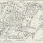
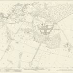
Essex (New Series 1913-) n LXXVIII.2 (includes: Woodford) - 25 Inch Map
1940
Ordnance Survey
1:3k
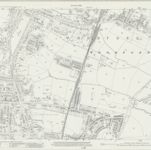
Essex (New Series 1913-) n LXXVIII.2 (includes: Woodford) - 25 Inch Map
1915
Ordnance Survey
1:3k
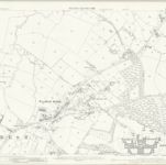
Essex (1st Ed/Rev 1862-96) LXV.8 (includes: Buckhurst Hill; Chigwell; Ilford; Woodford) - 25 Inch Map
1895
Ordnance Survey
1:3k
A colored plan, on vellum, of ""Luxbrough and Cocksall's Farms, situate in the parish of Chigwell and county of Essex; being the estate of Sir Joseph Eyles, Kent; surveyed and delineated by Thos. Browne, Gent., Blanch Lyon, Pursuivant of Arms, Anno Dom. 1727;"" with a separate plan of ""Browning's and Bird's Farms, situate in the manor of Wolston Hall and parish of Chigwell;"" drawn on a scale of 4 chains (of 72 yards) to an inch: the arms of Eyles impaling those of [Egerton?] are emblazoned at the top.
1727
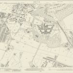
Essex LXV.NE - OS Six-Inch Map
1894
Ordnance Survey
1:11k
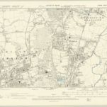
Essex (New Series 1913-) n LXXVIII.3 (includes: Chigwell; Ilford; Woodford) - 25 Inch Map
1939
Ordnance Survey
1:3k
Essex (New Series 1913-) n LXXVIII.3 (includes: Chigwell; Ilford; Woodford) - 25 Inch Map
1914
Ordnance Survey
1:3k
London IV.NW - OS Six-Inch Map
1893
Ordnance Survey
1:11k
London Sheet H - OS Six-Inch Map
1938
Ordnance Survey
1:11k
London Sheet H - OS Six-Inch Map
1914
Ordnance Survey
1:11k
Geschichte
Stare mapy Woodford, London
Objevte minulost Woodford, London na historických mapách
Stare mapy Woodford, London
Objevte minulost Woodford, London na historických mapách
Prozkoumejte mapy
Objevte historii
Nadřazená oblast
Hertfordshire
Související místa