Projekt
Komunita
Novinky
Moje aplikace
Moje mapy
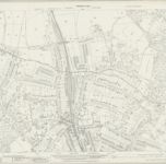
Hertfordshire XLIV.13 (includes: Harrow; Rickmansworth Urban; Ruislip; Watford Rural) - 25 Inch Map
1935
Ordnance Survey
1:3k
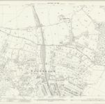
Hertfordshire XLIV.13 (includes: Harrow; Rickmansworth Urban; Ruislip; Watford Rural) - 25 Inch Map
1912
Ordnance Survey
1:3k
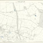
Middlesex V.13 (includes: Rickmansworth Urban; Ruislip; Watford Rural) - 25 Inch Map
1911
Ordnance Survey
1:3k
Middlesex V.13 (includes: Rickmansworth Urban; Ruislip; Watford Rural) - 25 Inch Map
1896
Ordnance Survey
1:3k
Hertfordshire XLIV.13 (includes: Harrow; Rickmansworth Urban; Ruislip; Watford Rural) - 25 Inch Map
1895
Ordnance Survey
1:3k
RAF Aerial Collection (1945 - 1949)
1947
RAF
1:10k
RAF Aerial Collection (1945 - 1949)
1946
RAF
1:5k
RAF Aerial Collection (1945 - 1949)
1946
RAF
1:5k
Hertfordshire XLIV.SW - OS Six-Inch Map
1938
Ordnance Survey
1:11k
Hertfordshire XLIV.SW - OS Six-Inch Map
1934
Ordnance Survey
1:11k
L'histoire
Stare mapy Northwood, London
Objevte minulost Northwood, London na historických mapách
Stare mapy Northwood, London
Objevte minulost Northwood, London na historických mapách
Prozkoumejte mapy
Objevte historii
Nadřazená oblast
Hillingdon
Související místa